I dont know if they did or they didn't but...Why do you presume they didn't do a good job?
...the Honda CRV Hybrid or Toyota Corolla Hybrid being on there but not their ICE counterparts really makes me question WTH is going on with their math.
I dont know if they did or they didn't but...Why do you presume they didn't do a good job?
...the Honda CRV Hybrid or Toyota Corolla Hybrid being on there but not their ICE counterparts really makes me question WTH is going on with their math.
Who's collecting those data?the discussion online about these numbers is still ongoing, here are some more numbers: "by end 2022, US MY miles driven >7B, M3 ~19B"
So at ~5 deaths per 1B mile driven, that would be like 35 deaths total in a model Y before end of 2022? Seems low. Though from this tracker, only ~300 deaths in or by a Tesla tracked by end of 2022: https://www.tesladeaths.com/, and the Model Y is only a fraction of that.
General Motors has announced that it will stop funding the development of the Cruise self-driving taxi.
The company says it will now "refocus autonomous driving development on personal vehicles".
I'm not seeing much optimism, esp. w.r.t. the cost of needed HW sensors to make sure there are no single points of failure, and how long it'll take to get to what usedto be called SAE L5 (no driver in vehicle, no user controls necessary).Not unexpected, but I'm super interested to hear from them or people in the team what caused the collapse of their self-driving branch. From a performance point of view they were certainly not trailing, they were leading along with Argo.ai and Waymo. It's clear that none are ready for prime-time, but there is still a surprising amount of optimism in the industry.
Not unexpected, but I'm super interested to hear from them or people in the team what caused the collapse of their self-driving branch.
Cruise had earlier pulled all of its US vehicles from testing after California halted its driverless testing permit.
In October 2023, one of its vehicles hit a pedestrian and dragged her for more than 20ft (6m), leaving her seriously injured.
Cruise admitted to submitting a false report to the National Highway Traffic Safety Administration in connection to that crash, resolving a criminal investigation last month.
Federal prosecutors said Cruise employees did not include a description of the pedestrian being dragged as part of their account on the morning after the incident.
Cruise co-founder Kyle Vogt left the company a few weeks later.
That can be done at L4.it'll take to get to what usedto be called SAE L5 (no driver in vehicle, no user controls necessary).
Forgive me for being cynical, but if they really think they'll pull 50 billion in revenue out of their robotaxis, they're probably going to find a way to overlook that as a rectifiable error rather than a showstopper. Especially because all their competitors also have blood on their hands, some quite a bit more.Sounds like the criminal case effectively ended the project last year, they laid off a lot of the team and now they're figuring out what to do with what's left of the company.
Full paper: https://storage.googleapis.com/waym...mo and Human-Driven Vehicles at 25M miles.pdfcompared to human-driven vehicles
Full paper: https://storage.googleapis.com/waymo-uploads/files/documents/safety/Comparison of Waymo and Human-Driven Vehicles at 25M miles.pdf
What I can't find:
Waymo is currently limited to low speed and non highway roads. How did they segment the insurance data to get only the city driving miles out of it?
I guess it's still better than Tesla's comparison, highway miles vs mixed, as cities cause more accidents, but either way it's not a apples to apples comparison.
What? There's a safety process? I thought everybody was just YOLOing it.https://blog.aurora.tech/safety/preparing-for-driverless-operations
Aurora just published a white paper on their safety process, in advance of plans to launch operator-free operations.
Can't tell if serious.What? There's a safety process? I thought everybody was just YOLOing it.
Nevertheless, Waymo ran over and dragged a pedestrian. So I guess?Can't tell if serious.
Waymo, Cruise, and Aurora, at least, have all been quite methodical about their development and its implications. Uber, Tesla, et al have obviously not been. No idea about how the Chinese or other ones are approaching things.
Yes, you are correct.I think that was Cruise which dragged a pedestrian.


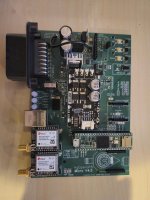
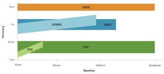
You're literally doing dGPS, but with DIY stuff. That's amazing. dGPS receivers end up being about 1cm accurate if you integrate for long enough, but they cost a lot more. RTK is another word for dGPS using not just GPS satellites but also the glonass etc. satellites.RTK is siginifcantly more accurate than dGPS
(...)
My understanding is that because the base knows exactly where it is, any atmospheric interference will affect receivers the same in a given region. So the base says "Hey you're getting this data from these GPS sats (it can only correct for data from shared visible birds) but you actually need to adjust what you think about the data from those by XXX because I know where I am and I can see the interference"
tl;dr we should get roughly 1-2" of repeatable year over year row over row accuracy.
In China there's very agressive censoring of anything bad related to Tesla. One of the major chiefs is a Musk fan and they are grateful for the tech transfer making the country the leader / top x in battery and EV tech.Tesla released the FSD version in China recently and a lot of Chinese videos are up comparing the various Chinese ADAS vs FSD. The ones I've seen are mostly favorable to FSD but who knows for real.
Either way, Tesla is probably the only US company that can compete in the ADAS/FSD world. Could be BYD or Huawei or similar wins out in the end.
Tesla released the FSD version in China recently and a lot of Chinese videos are up comparing the various Chinese ADAS vs FSD. The ones I've seen are mostly favorable to FSD but who knows for real.
Either way, Tesla is probably the only US company that can compete in the ADAS/FSD world. Could be BYD or Huawei or similar wins out in the end.
Hesai's Chief Financial Officer Andrew Fan told Reuters on Tuesday in an interview after its quarterly earnings that it was a commercial decision by the partner. He also declined to name the company.
"I assume the automaker has to find alternatives that can be comparable to Hesai's products on performance and price but the result is there is none," Fan said.
European makers have used Hesai as a lidar supplier for their models sold in China, he added.
Hesai has been expanding two production lines in China to achieve an annual capacity of more than 2 million units this year to meet the rising demand, Fan said.
It is also setting up production lines overseas with a target to launch them as early as next year to serve its clients out of China concerned about tariff and logistics risks, Fan said. He declined to say where the overseas factory will be located.
Demand for lidar is increasing in the highly-competitive Chinese market as automakers increasingly offer smart features on affordable models.
On Monday, Leapmotor (9863.HK), opens new tab started sales of its B10 SUV with an advanced smart driving feature from $17,950.
The car is equipped with Hesai's ATX lidar, which cost around $200 each, less expensive than safety belts and airbags, Fan said.
Mercedes-Benz will add lidar sensors to “a broad range” of its vehicles by the middle of the decade, the company announced at an investor event in California on Wednesday. The laser sensors will help power the German automaker’s next-generation driver-assist system, which allows for hands-free unsupervised driving on certain highways.
The lidar will be supplied by Luminar, a Florida-based company in which Mercedes owns a small investment stake. The German automaker has no plans to increase its stake in Luminar, though the lidar deal is said to be worth several billion dollars. (Mercedes owns less than 1 percent of the company.)
The German automaker has no plans to increase its stake in Luminar
Mercedes is the latest automaker to commit to selling vehicles to customers with rooftop lidar sensors. The laser sensor, a key component in the suites used by most autonomous vehicles, employs near-infrared light to detect the shapes and distances of objects.
Combined with camera images and other sensor data, lidar helps vehicles “see” other objects on the road, like cars, pedestrians, and cyclists, all without the help of GPS or a network connection.
The expanded deal will mean expanding Luminar’s manufacturing footprint to include a factory in Asia. The factory will “almost entirely be dedicated to supporting the Mercedes series production program,” Luminar’s spokesperson said.
Increasing production and reducing costs will be key goals in the early stages of the partnership. Lidar can be incredibly expensive — the rooftop versions sold by industry leader Velodyne can cost as much as $75,000 — but Luminar has said it aims to reduce the cost to as little as $500 a unit for advanced driver-assistance system applications and around $1,000 a unit for autonomous applications.
Unfortunate. Plain old camera vision systems can't compete with lidar for object recognition or seeing though rain, fog, and snow.random data point "As with the P7+ sedan launched last year, Xpeng has removed LiDAR from the updated G6 and G9, with the smart driving system shifting to a pure vision solution."
It needs to be really aggressive unless it's truly ready for SAE Level 5, and it's not. That annoying driver monitoring and reluctance to engage if everything is not right is saving your life.It feels really silly but…I just got yet another week long strikeout for Tesla self driving. I really do not like tesla auto steer. It is way too cautious and it seems geared more towards minimizing possible liability for Tesla rather than being useful.
kind of thinking of installing a comma3x in the Tesla. Ridiculous, but Tesla‘s driver monitoring is way too aggressive and it won’t turn on half the time.
Actually, no, I disagree. I have a comma.ai which has significantly less compute and fewer cameras. The comma.ai handles those situations just fine. The Tesla could too— i think hw4 is like the equivalent of a ps5 or something? The comma3x in comparison uses a snapdragon 845 which might be as powerful as a ps2 or something. It handles all of those situations just fine.It needs to be really aggressive unless it's truly ready for SAE Level 5, and it's not. That annoying driver monitoring and reluctance to engage if everything is not right is saving your life.
